


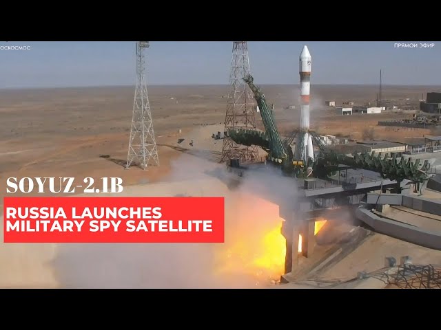
On March 31 last year, the Russian Soyuz-2.1b rocket sent the latest spy satellite, Resurs-P, into space. Nine months later, on January 3, 2025, Roscosmos shared the first images and features of the Geoton-L1 equipment, which is the main tool for observing the Earth’s surface in high detail.
Roscosmos released four photos—two of Los Angeles in the USA and two of the Burj Khalifa in Dubai, UAE. These images refute doubts about Geoton-L1’s capability to capture clear photos, as the images shared are truly impressive.
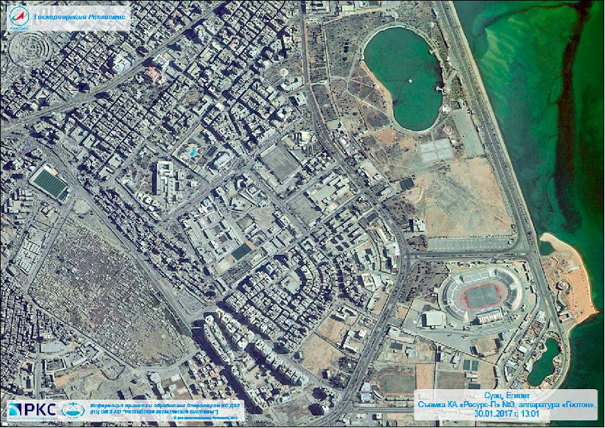
The image from Roscosmos of Los Angeles shows SoFi Stadium with fine detail. This venue is in the Inglewood area and hosts two NFL teams — the Los Angeles Rams and the Los Angeles Chargers. SoFi Stadium also holds events like American football, concerts, and big happenings like the Super Bowl, featuring top artists. The venue is modern with diverse entertainment options.
The Resurs-P spy satellite and Geoton-L1 are high-resolution Russian satellite technologies aimed at remote sensing and gathering data from the Earth. This technology is part of Russia’s aim to boost its intelligence and strategic surveillance capabilities, providing clear and precise images.
The system is vital for observing military sites, critical infrastructure, and natural resources, making it significant for Russia’s geopolitical goals. Geoton-L1 can be used for both military surveillance and monitoring climate change or natural disasters.
Resurs-P spy satellite Strategic Edge
Such satellite systems give a strategic edge, allowing Russia to observe thoroughly and act on incoming data in real time. The ability to obtain this information equips Moscow with tools to evaluate the status of crucial sites and make informed decisions for military and intelligence operations. Geoton-L1 fits into Russia’s larger satellite framework aimed at improving national security and keeping control over vital regions.
This system plays a crucial role in today’s conflicts, helping Russia quickly assess situations vital to national security. Geoton-L1 deserves greater attention, as it leads Russia’s satellite surveillance missions.
This high-resolution system is central to Russia’s current military strategy, especially amid tensions with NATO and the war in Ukraine. It enables Russia to observe and analyse key ground targets with precision.
Satellites like Geoton-L1 support tracking troop movements, evaluating enemy strength, and planning responses. If conflict erupts with the U.S., Geoton-L1 can monitor and analyse American military positions in real time.
It captures detailed images of high-value sites, including military bases, airfields, and infrastructure. Geoton-L1 can spot strategic U.S. locations both within American borders and at overseas installations.
Observing these locations gives Russia important intelligence on operations and possible targets. Satellites can identify sites like missile silos, command centres, supply hubs, and radar stations.
Spotting construction activity or troop buildup helps Russia anticipate future actions or deployments. This kind of surveillance provides essential data for shaping battlefield decisions and long-term military planning.
Resurs-P spy satellite and US mobile military forces
Using satellite technology, it is possible to watch key military transport routes that the US might use to move troops and gear if military action happens. Seeing military convoys, troops moving through important areas, or activities at airports would help Russia guess where attacks or mobilisations might happen.
Geoton-L1 has the capability to monitor nuclear weapons, mid-range missiles, strategic submarines, and bombers. The ability to see the building or moving of important weapons gives Russia insight into possible US attacks and allows for defensive actions. The satellite system can observe and assess the movement of US mobile military forces.
The data includes tanks, combat ships, and aeroplanes, which helps Russia form expectations about threats and plan tactical responses. Geoton-L1 could also be important for strategic cyber intelligence.
By watching communication systems and satellite links, Russia could follow US actions in cyber warfare. Noticing signals and conversations in real time could allow for efforts to disable or disrupt vital American communication links.
Geoton-L1 would also be crucial regarding the situation in Ukraine, especially concerning Russia and NATO. The ability to watch NATO troop movements in Europe is key for Russia since it aids strategic planning and responses to any possible aggression.
Russia may use high-resolution satellites to track NATO troops near its borders. This includes observing military activities, the setup of new bases, and the placement of combat units and equipment. Any new stage of NATO’s military presence can be seen and recorded by Geoton-L1, helping Russia determine the military resources required for defensive or counteroffensive operations.
Resurs-P spy satellite and Geoton-L1
NATO troops stationed in Eastern Europe and Ukraine require regular supplies of fuel, ammunition, food, and other necessary support. Geoton-L1 can watch and trace these deliveries and the routes they use. This enables Russia to foresee and possibly strike crucial logistical networks that could hinder NATO’s efforts.
By monitoring NATO’s local military actions, Geoton-L1 could offer details on troop numbers, the gear used, and trials of new equipment or tactics. Watching joint NATO drills could also help Russia adjust its military plans and prepare for responses if tensions rise.
High-resolution satellites like Geoton-L1 can detect all troop activities and military resources in Ukraine, including incoming NATO reinforcements or support from other Western nations. Satellites can also track the movement of ammunition, gear, and resources, allowing Russia to see how much backing the Ukrainian army is receiving.
Geoton-L1 could also monitor critical infrastructure, such as power stations, water systems, and transport centres that are essential for Ukraine and NATO. Knowing where these sites are allows Russia to plan targeted strikes that disrupt the enemy’s logistical systems and complicate NATO operations.
Conclusion
NATO has various military setups and resources spread across Europe. GeoL1 can help identify new bases, training centres, or strategic positions NATO may establish to bolster its presence against Russia. The satellite system could also observe all necessary steps for the construction or expansion of these sites. Geoton-L1 may provide valuable data on the movement of air and naval forces used by NATO in the area.
This function consists of monitoring planes, military helicopters, boats, and submarines, along with identifying new changes in critical air or sea resources. This allows Russia to respond and devise strategic attacks.
Geoton-L1 presents Russia a strategic edge by allowing it to observe and assess enemy actions in real time across the US and Europe. The surveillance furnishes the Kremlin with essential information for formulating tactics, launches, and defensive actions, which is important in today’s warfare.
References
- Resurs-P Earth Observation Mission – eoportal.org/resurs-p
- Geoton-L1 Instrument Details – space.oscar.wmo.int/geoton
- Resurs-P Satellites Overview – skyrocket.de/resurs-p


